|
  
|
Decoding the Carolina BaysSkeptoid Podcast #839 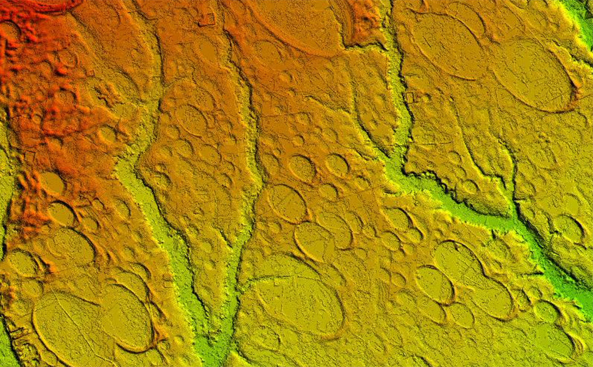 by Brian Dunning Today we're going to have a look at a minor geological mystery, involving thousands of truly perplexing formations, some science, some pseudoscience, and a lot of genuine curiosity. We've known about the Carolina Bays for more than a century, and for most of that time we've had no great ideas about how they came to be. We've had some bad ideas, and some of those still persist today — for reasons that, as we'll find out, are pretty interesting. The temptation to find an explanation for hundreds of thousands of structures all over the United States' eastern coast is a strong one, especially when those explanations can also serve to bolster an unrelated theory. Regardless, today we're going to do our best to find out what we actually do know about the Carolina Bays, and how we know it. If this doesn't sound like a very interesting mystery to you, have a look at the characteristics of the bays. The total number of them does indeed range all the way up into the hundreds of thousands; with quite a lot fewer being particularly distinct, numbering probably in the thousands. At the lowest end, some sources say there are some 900 "notable" bays that remain pristine and are not impacted by development, most of them in North Carolina. Obviously there's no firm place to draw the line; suffice it to say there are a lot of them, ranging from New York to Florida. They are depressions, almost as if they were carefully cut into the soil like golf course water traps. Some are as small as ten meters across; the biggest measure as much as five kilometers. They have sand berms along the southeast and northeast shores. Most are not filled with water, but some are. Despite the water, one should not read anything into the name bay. They are not bays in the conventional sense. One early researcher (1895) used the term because the ones in his area were all filled with water. Some are associated with bay trees in or near them. Regardless, the name stuck, if for no other reason than lack of something better. Their strangest traits they share are that they all have a nearly identical oval shape, with a width-to-length ratio averaging .58; and a similar directional orientation, with their long axis running northwest to southeast. However, this shared orientation is not nearly so uniform as is usually claimed in consumer articles about them. The southernmost bays, running approximately from Georgia up through Virginia, have their long axes pointing generally northwest — averaging about 344° at the south end and about 296° at the north end. The individual variance throughout the region is somewhere around 10-15°, so it's not a perfect distribution. But if you were to extend an imaginary line northwest through the long axes of all these bays, those lines would converge around Cincinnati, Ohio. This is weird, but probably just coincidental; I'm sure somebody has tried to find some cosmic significance in that, but not that I ran across. North of Virginia, however, that pattern vanishes. At first the bays are oriented generally northeast, but as you continue moving north up through New York, their orientations become essentially random with no clear pattern. The central question around the Carolina Bays is what caused them. How were they formed? This regional similarity in orientation is the first clue, so let's see where researchers have run with that. In 1987, geographer Thomas Ross published an article titled "A Comprehensive Bibliography of the Carolina Bays Literature" in which he listed fully 18 different theories, going all the way back into the late 1800s. Some of them were similar so I've done a bit of consolidation here, but this is basically the list; and as you can see, many of these are completely nonsensical:
One of these explanations is commonly given, either as an alternative explanation, or in some sources as the only explanation — and it's also wrong. Can you guess which one it is? Well, we'll start with that one. Through the 1950s or so, it was generally believed that the Carolina Bays were impact craters from a swarm of meteors. Some still believe this today; in fact, they even have it nailed down to a particular impact event — a hypothetical one called the Younger Dryas impact. So let's sidebar for a really quick refresher on the Younger Dryas period. At the end of the last ice age, temperatures rose to get back up to normal. But all of a sudden, temperatures dropped back down to ice age weather for 1,200 years. What could have caused this? When the Laurentide Ice Sheet (covering much of the United States and Canada) melted at the end of the last ice age, countless gigatons of cold water flowed into the Atlantic Ocean. This influx blocked the normal northward current of warm equatorial water — an important current called the North Atlantic Conveyor which plays a crucial role in global climate. Now, there's no doubt that this happened — that ice sheet was there, it did melt, and the Atlantic is where a lot of its water went — but there are still fringe claims that the effect was not strong enough to have caused the Younger Dryas cold spell, and thus an alternative explanation must still lie undiscovered somewhere. Perhaps the most popular of these alternative fringe theories (popular probably because of its dramatic and theatrical nature) is called the Younger Dryas impact hypothesis, which posits that some enormous meteor impact must have filled the Earth's skies with dust sufficient to keep it cold for more than a thousand years. Although there are controversial interpretations of various layers in sediments around the world claimed as evidence for this, the obvious lack of a crater — or group of many small craters — is the biggest hole in the hypothesis (no pun intended). And, of course, any exotic explanation is unnecessary, given the reality of the glacial meltwater. We've talked about the Younger Dryas impact hypothesis before, notably in episode #724 on the Turkish archaeological site Göbekli Tepe. It's a favorite of many in the alternative history crowd, such as the infamous woo-broker Graham Hancock, who wrangle the provocative allure of the impact hypothesis and its dramatic effects into evidence in favor of crackpot theories of ancient Atlanteans or whatever their jam might be. We see the exact same connection with the Carolina Bays. Some alternative theorists posit that the bays are craters left when some enormous meteor or comet, broken up in space, shattered the Atlantic seaboard with a shotgun blast of catastrophic impacts. However, geologists and geomorphologists have thoroughly disproven this theory of the origins of the Carolina Bays. There are just too many characteristics of the bays that are irreconcilable with impact craters. Here are a few points:
Finding all of these problems with the impact hypothesis gave the geomorphologists most of what they needed to finally solve the puzzle once and for all, and to determine the true origin of the Carolina Bays. Here are two clues for you:
Can you guess the answer from those clues? The Carolina Bays are relict thermokarst lakes, formed during the ice ages, by the same process we can observe today at the similar lakes in the northern latitudes. As frozen ground begins to thaw, a resulting puddle becomes a pond which becomes a lake. Prevailing winds keep the water lapping at the lee shore, pushing sand up against it and pulling the lake back toward the direction of the wind, and thus forming the distinctive oval shape. Given the prevailing seasonal wind directions at those times in history, the sand berms along the southeast and northeast shores are exactly where we'd expect to find them. Beyond that geomorphology, the other data we've collected also supports the thermokarst lake theory. Dating of the sediments shows that the bays were formed at the same times in history when we already know that ground was thawing, and the palynology shows the same concentrations of various flora already known to have flourished at those times. The bays are all ancient and no longer being formed because the ground is no longer frozen and thawing. But in the northern latitudes, where there is still permafrost with seasonal thawing, we see the same kind of thermokarst lakes in the same state of formation you could witness if you went back in time tens of thousands of years to watch the Carolina Bays being formed. And so we have the solution to a relatively simple detective story, but one that is still plagued to some degree by the older, disproven solution still being given by some sources. This problem is not merely a complication to those seeking information on the bays, because the old explanation's persistence forms a puzzle piece misused to bolster outright pseudoscience and pseudohistory such as ancient advanced civilizations. The tendency for various branches of misinformation to share common roots, and to lead a curious person from one into another, is a compelling reason to weed out all misinformation wherever it takes root. The true geological history of the Carolina Bays give us yet one more reminder that you should always be skeptical.
Cite this article:
©2025 Skeptoid Media, Inc. All Rights Reserved. |