|
  
|
The Treasure of Victorio Peak, Part 2The hunt for the greatest treasure of gold ever imagined. Skeptoid Podcast #881 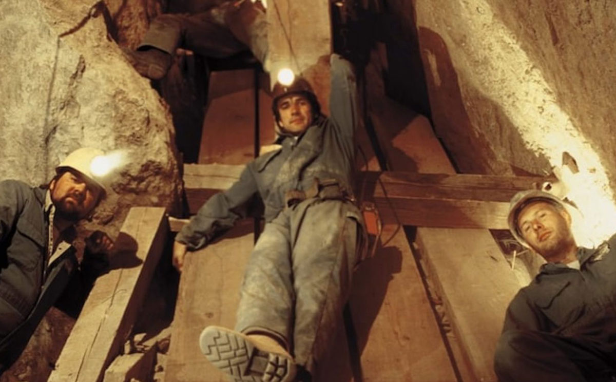 by Brian Dunning Today we're going to continue our skeptical analysis of the treasure of Victorio Peak, as presented by the 2023 Discovery Channel miniseries Gold, Lies, & Videotape. If you haven't heard Part 1, I strongly recommend you go back and listen to that one instead, as there's a lot of information and it doesn't make sense to try and recap all of it. Where we left off, the US Army had formed White Sands Missile Range and incorporated the land on which Victorio Peak is located. This prevented Doc Noss and his friends and family from continuing their search for the fantastic treasure cavern, inside of which Doc claimed to have found 16,000 bars of gold. It was 1973 when the story exploded back into the public consciousness, via a source nobody would have guessed. During the televised Watergate hearings, buried amid the countless hours of testimony was a reference to a guy who had approached President Richard Nixon's staff back in 1970 claiming to have secret knowledge of a large stash of gold — adding a new element to the story, which was that perhaps Nixon himself had directed the gold to be secretly stolen. The newspapers all went into a frenzy and suddenly Victorio Peak was back on everyone's mind. White Sands was deluged with demands to grant access. Celebrity attorney F. Lee Bailey represented some fifty different parties all claiming ownership of the gold — nicknamed the "Filthy Fifty" by the press. And so White Sands caved, and in 1977 they created Operation Goldfinder; and to keep it organized, they brought in Norman Scott of Expeditions Unlimited to lead it. Expeditions Unlimited had made a name for itself doing some high profile underwater treasure hunting on sunken ships for National Geographic. Scott even had a claimant of his own: he was representing Doc's random second wife, whom someone had managed to track down and asserted that she was the legal heir to Doc's claim. Operation Goldfinder was a ridiculous media circus. Even Babe was there herself with some of her family. Countless randos swarmed the mountain for 10 days with cameras everywhere; Scott persuaded the Army to extend it to 13 days. And you can guess what was found: nothing at all. And so it was soon forgotten again, this time for more than a decade. Then in 1989, the TV show Unsolved Mysteries covered the treasure of Victorio Peak. They had a hotline you could call at the end of every episode in case you had some information on one of their cases — and you can guess who called it. Random claimants to the gold, of course; but also more guys claiming to have been soldiers at White Sands and to have seen the gold. Some of these were featured on the Discovery Channel miniseries. One, a B.A. Davis, says he was part of the White Sands 1961 work crew that removed much of the gold, and were all threatened never to speak of it — so of course, here he was speaking freely about it. The Discovery Channel tried to check up on his story and found that he'd never been in the military at all. His explanation was that this was proof that what he was saying was true; the military had erased his records in retaliation for his speaking about the gold. Rule of thumb: Whenever anyone "comes forward" years after an event claiming to have been a part of it, your default assumption should always be that they are full of buffalo caca. Meanwhile, Babe's grandson Terry Delonas, who had assumed the mantle of being the family's official representative, had been grinding himself into the dirt trying to deal with the Pentagon to get permission to resume work on Babe's mining claim. Well, apparently the notoriety generated by Unsolved Mysteries did it. The Ova Noss Family Partnership was formed with significant friends & family financing in place, and they were at last granted permission to resume work in 1992 — under daily supervision by military police. A young filmmaker, Alex Alonso, documented their work over the next four years. His footage forms much of the 2023 Discovery Channel miniseries, which he also produced. And so years of work consumed the Family Partnership, filled with tribulations and setbacks. They engaged geophysicists to do seismic surveys of Victorio Peak and found what the family believes to be the probable location of Doc's treasure cavern. They hired miners to tunnel their way to it… and just when they were within meters, the Army pulled the plug and kicked them out. The Army said it was for non-payment of the agreed costs; the Family Partnership said all the money mysteriously disappeared from their account. Either way, the show was over, and over for good this time. Fast forward 30 years, and Alonso and Delonas aired their miniseries on Discovery. It's well done and entertaining, but leaves little doubt that it's a thinly veiled infomercial seeking more investment and official permission to return. And then I heard from many of you asking for a skeptical treatment of the tale, and, well, here we are. Anytime I have a legend about an old mine or cave or any such thing, one of my first steps is to find out the true geology of the location. So I grabbed Skeptoid's consulting geologist, Andrew Dunning, M.S., briefed him on the legend, and turned him loose to dig through the literature and the geologic map databases and learn everything we could about the plausibility of the Doc Noss story. It turns out that one paper has actually been written about Victorio Peak itself — which on the one hand, is surprising; because it's a very small little knob with little significance, and is the last thing a geologist working in the area would study. But on the other hand, in this case it was inevitable, because it was written in 1994 — when The Ova Noss Family Partnership was at the mountain. It was prepared at their direction, a wise move. It is, however, an odd paper, perhaps due to the fact that it was written for the Family Partnership and not for publication. We'll get to the paper's intriguing oddities in a moment. So here's the basic geological plot. Victorio Peak is a little limestone knob of what was once a great coral reef in an ancient seabed, later covered by silt which mostly eroded away. Later, after that coral had morphed into limestone under heat and pressure, an intrusion of molten granite thrust up through it. This presents today as a plane, several meters thick, standing on its edge, cutting right through the middle of the peak in an east-west orientation. If you look at Victorio Peak on mapping software, you can see this line continuing a bit to the east of the peak and farther to the west. It also forms the prominent cut right across the top of the peak. A few meters to the north of this intrusion is a fracture. When the molten granite thrust up through the peak, it split the top part causing a system of fractures. When rock fractures from pressure, it does so perpendicular to the direction of the pressure. Think of a loaf of sliced bread; if you separate it in the middle (representing the pressure from the igneous intrusion), all the other slices on both sides are how the rock would fracture. Such intrusions bring a lot of water with them, and this water gets into those fractures and dissolves away the limestone. That's how Victorio Peak's famous fissure was formed: it's the next slice of bread a few meters north from the igneous intrusion, and mirroring its orientation. This fissure is generally some 1-2 meters wide, and it cuts the knob in half like you took a knife to a cake. Where it breaks the surface has mostly been filled in with sediment and debris, so you don't necessarily see it walking around outside. But it turns out to be perfectly plausible that Doc Noss stumbled upon a place at the top of the knob where it was exposed and he could climb down into it. Once inside, that fissure would be much like one of those toy ant farms between two panes of glass, with various places where it was clogged with debris, and probably lots of places Doc could have crawled to explore, and gone further and further down. But not all that far. About 50 meters is all, in fact — below that is a solid floor of shale, still well above the base of the knob. The shale would not have dissolved as the limestone did. Doc could have crawled back and forth east and west in that fissure, but probably not north or south or down. And Doc, by himself, probably couldn't have gotten near to that shale. Much of the bottom of the fissure was deeply buried with debris, which would have been beyond one man to remove on his own. The Discovery Channel documentary details two stages of seismic survey work done at the site by geophysicists working for the Family Partnership. The first one was done horizontally: they covered one wall of the fissure with a grid of geophones and set off explosive charges on the surface outside, which would give a full 3D picture of the interior of the knob, as far down as that shale floor. No giant caverns appeared. On the show, the Family Partnership people explained that this survey was not 3D and that they'd need a vertical survey too. Watching this, consulting geologist Andrew was jumping up and down in protest, because of course that survey gave 3D data; it just didn't show what the Family Partnership wanted it to show. So the geophysicists brought in a new team to drill horizontally under the peak, perpendicular to the fissure. A line of hydrophones were placed every 3 meters inside a flooded tube in that horizontal borehole, and explosive charges were set off at the peak's summit. What did that second survey show? Sadly you're going to have to wait until next week's episode to find out, but suffice it to say that it was interesting enough that the geophysicists elected to put contradictory information into their paper detailing the survey, and also made some omissions that — by existing as omissions — ended up giving us a pretty good idea of what was actually going on beneath Victorio Peak. What was it? Tune in next week to Skeptoid to find out. Special thanks to consulting geologist Andrew Dunning, M.S.
Cite this article:
©2025 Skeptoid Media, Inc. All Rights Reserved. |