|
The Sargasso Sea and the Pacific Garbage PatchSkeptoid Podcast
#132 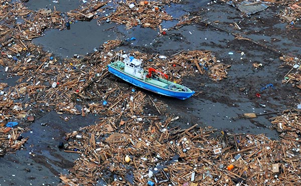 Today we're going to sail the oceans blue, through the wind and spray, at least until we become mired in two remote wastelands said to be the bane of mariners: The Sargasso Sea in the middle of the Atlantic, and its companion on the other side of the globe, the Pacific Trash Vortex. Both areas are encircled by swirling ocean currents, and are said to collect their debris in the center. Both are the subject of tall tales. Both are ripe for skeptical inquiry. The Sargasso SeaLet's start in the Atlantic. The Sargasso Sea is actually a named sea, and it's the only one in the world with no shorelines, being completely enclosed within the North Atlantic Ocean. It's a 2,000,000 square mile oblong oval stretching across the Atlantic, centered on about 30°N latitude, bounded by major clockwise ocean currents. It's best known in stories for being a dense mat of solid seaweed, a tangled mass that no ship can penetrate. You hear tell of ancient mariners finding abandoned wrecks trapped, or starving crews who tried to walk out. Most famously, Christopher Columbus wrote about the Sargasso Sea in his log. Upon encountering the seaweed, he thought he must be near land, but when no land appeared after days of sailing his crew almost mutineed. Jules Verne's Nautilus visited the Sargasso in his novel 20,000 Leagues Under the Sea:
In 1910, the steamer Michael Sars took a party of scientists out to study the Sargasso Sea for three months, and their report was among the first that debunked these legends. They found the patches of seaweed to be small and sparse, rarely larger than a doormat, and in no way a hazard to navigation. They also found the waters of the Sargasso Sea to be warmer, clearer, bluer, and with less oxygen than the surrounding Atlantic. For this reason they declared the Sargasso Sea to be a type of desert, largely bereft of sealife. This notion was challenged in 2007 when research published in the journal Science found that phytoplankton blooms were the reason for the decreased oxygen. The rotation of the huge eddy draws up salty, nutrient rich water from the ocean floor, enriching the sunlit upper layers of water, and kick-starting an unusually active ecosystem. Thus the Sargasso "desert" is actually quite the opposite, and the relative proliferation of sargassum seaweed is due to nutrient rich growing conditions, not vortex suction action. What of the tall tales of ships becoming trapped, and stranded sailors dying? It so happens that the Sargasso Sea is a convergence of several conditions, not just the nutrients from the deep, but also weather conditions at its latitude. 30-35° latitude, both North and South, is the location of the subtropical ridge between the trade winds. Conditions here are variable winds and low precipitation. Sailors call it the doldrums. Sailing vessels entering the Sargasso Sea are virtually certain to come to a grinding halt in a dead calm. Throw in some strange seaweed and we have all the ingredients for a nautical epic. The Pacific Garbage PatchBut if we spin the globe and look at the center of the North Pacific Ocean, we see a phenomenon that is due to vortex suction — the Pacific Trash Vortex, also called the Pacific Garbage Patch. One guy emailed me that he'd looked for it on Google Earth; he'd heard there was a giant island of solid floating garbage twice the size of Texas in the middle of the Pacific Ocean. The North Pacific Gyre is a clockwise rotation of ocean currents in the North Pacific. Wind and currents combine to drive floating matter toward its center. You might have heard of the Pacific Garbage Patch before, and are probably just now wondering why you've never seen any photographs of a giant island of trash. In fact, Hawaii is right in the center of the Gyre, and if there were a Pacific Garbage Patch, Hawaii would be in its exact center. The answer is simple: No such floating island of trash exists. Despite the fact that there is a huge amount of plastic waste in the Pacific Ocean, and despite the fact that the Gyre does drive it all toward the center, there is no floating island. How do we corroborate these two seemingly mutually exclusive facts? One proposed explanation, put forward in a map created by Greenpeace, shows the garbage patch as two separate patches on either side of Hawaii, both well clear of it; thus nobody ever sees them. The map also gets East and West reversed, and is dramatically wrong in its depiction of ocean currents, splitting the North Pacific into two counterrotating swirls, instead of one big one like it actually is. So let's set aside Greenpeace's claim for the moment, and go back to the origin of the story. In 1988, Robert Day, David Shaw, and Steven Ignell submitted a report to NOAA (National Oceanic and Atmospheric Administration) detailing the results of four years of sample collection and analysis of plastic fragments found floating in the Pacific Ocean. They found concentrations highest in the North Pacific Gyre. The authors cited wind and currents as the primary force driving the higher concentrations to the center of the Gyre. Concentrations of what? Number one, monofilament fishing line fragments; and number two, something called neuston plastic. Neuston plastic refers to particles that have been broken down to a small size and are now floating just at or below the surface of the water. Most plastic floating in the open ocean degrades quite quickly, due primarily to ultraviolet radiation. It becomes brittle and crumbles. When it reaches microscopic size, it competes with phytoplankton as a food source for zooplankton, and enters the food chain. That's not good for anyone. The authors used 203 sample stations, each about 450 square meters in size. 52.2% of these contained plastic fragments. Got that? Only half of NOAA's football-field sized sample areas, in the center of the densest part of the Pacific "Garbage Patch", contain even detectable levels of microscopic plastic. Unacceptable to be sure; but hardly a solid island. The reason is that getting to the center of the Gyre takes more than enough time for plastic to break down. Oceanographer and sailor Charles Moore estimates that garbage from Asia takes about one year to reach the Gyre, and about five years from the United States. Moore is largely responsible for bringing the issue into the public eye. Upon his return voyage from the 1997 Transpac ocean race from California to Hawaii, he wrote:
Although Moore is doing important work, some of his more overly dramatic descriptions like this one have helped to launch the popular belief in Texas sized garbage patches. Bringing attention to the issue is good; presenting an overdramatized representation of the facts to do so, not so much. Now, I'm not here to defend the dumping of trash at sea, which is the default criticism I'm going to receive for pointing out that there is no Texas-sized island of trash surrounding Hawaii. I remember once while sailing from Newport Beach to Cabo San Lucas, about 100 miles offshore we crossed the path of a cruise ship that had passed in the night. It actually left a visible path: mainly an oil slick, dotted with party balloons, plastic cups, and other junk. Very nice. I also remember the first time I saw a garbage scow being towed out to sea, loaded with an acre of trash, to be dumped. I grabbed a marine chart and saw there was actually a marked area offshore designated for such dumping. I couldn't believe it. So while I do have opinions on the subject, on Skeptoid we focus on the truth of the stories about huge islands of trash floating in the middle of the Pacific. And the truth is there isn't one.
Cite this article:
©2024 Skeptoid Media, Inc. All Rights Reserved. |